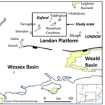
Three Fingers of Lower Greensand near Oxford, -each telling a different story, Tuesday 20th October
A talk by Nigel Banks
A rise in sea level during the Aptian (early Cretaceous) flooded parts of the London Platform depositing isolated pockets of sand-rich sediments across an eroded surface. These deposits make up the Lower Greensand Group which represents the base of a transgressive megasequence that culminates in the Chalk.
The three sands in Oxfordshire, near Faringdon, Nuneham Courtney and Tiddington have been mapped in the subsurface. Each shows strikingly different thicknesses and geometries, only partially related to the amount of erosion of the underlying Upper Jurassic section. Despite this improved understanding, many mysteries remain!
20th October 2026
6.30 to 7.30 pm Westwood Room, OU Museum of Natural History
All welcome – free to attend.
We would kindly ask for a voluntary donation of £5 or more (cash or card) to allow us to
continue this lecture series. This will be gratefully received.
For visitor information see https://oumnh.ox.ac.uk/visit-us
The Oxford University Museum of Natural History Parks Road, Oxford, OX1 3PW

GEOX lecture Tuesday 17th November
Ichthyosaurs
details to follow
17th November 2026
6.30 to 7.30 pm Westwood Room, OU Museum of Natural History
All welcome – free to attend.
We would kindly ask for a voluntary donation of £5 or more (cash or card) to allow us to
continue this lecture series. This will be gratefully received.
For visitor information see https://oumnh.ox.ac.uk/visit-us
The Oxford University Museum of Natural History Parks Road, Oxford, OX1 3PW
OGT Annual General Meeting Thursday November 19th
Find out about OGT future activities
19th November 2026
Location to be confirmed
GEOX lecture, Tuesday 15th December
Earthquakes
Details to be confirmed
15th December 2026
6.30 to 7.30 pm Westwood Room, OU Museum of Natural History
All welcome – free to attend.
We would kindly ask for a voluntary donation of £5 or more (cash or card) to allow us to
continue this lecture series. This will be gratefully received.
For visitor information see https://oumnh.ox.ac.uk/visit-us
The Oxford University Museum of Natural History Parks Road, Oxford, OX1 3PW